

免费咨询留学:400-697-9728
服务监督热线:400-821-8688


大地测量与测绘工程哲学博士
Doctor of Philosophy in Geodesy and Geomatics Engineering

 加拿大
加拿大
学历文凭
Ph.D.

专业院系
Geodesy and Geomatics Department

开学时间
16 May 2024

课程时长
2 Year(s)

课程学费
CAD 41,121

国际学生入学条件
MEng and MScE applicants should hold an undergraduate degree in a related field geology,physics, math, engineering, and science from an accredited University. PhD applicants should hold a Master's degree in geodesy and/or geomatics, or have related experience.
All applicants should have a minimum 3.0 (or B Average, 70%)
Applicants are required to submit a complete application including three references.
International applicants whose first language is not English must submit language scores that meet or exceed international English language testing system (IELTS) band 7 and/or a TOEFL score of 92.
We offer a post-graduate diploma in Mapping/Charting which is only available for members of the Canadian Forces Department of National Defense.
展开
IDP—雅思考试联合主办方

雅思考试总分
7.0
了解更多
雅思考试指南
- 雅思总分:7
- 托福网考总分:92
- 托福笔试总分:160
- 其他语言考试:NA
CRICOS代码:
申请截止日期: 请与IDP顾问联系以获取详细信息。
课程简介
UNB的大地测量与大地测量工程(GGE)研究生课程将大地测量学与大地测量相结合,使学生对该领域有了全面的了解。我们提供跨学科的,实用的方法,将这些学科与地质,物理学,土木工程,海洋学和法学等其他学科相关联。我们的顶级国际知名部门为学生提供访问相关研究中心和最新大地测量仪器的途径。全球有500余名学生从GGE获得了研究生学位,然后成为全球公认的大学研究机构,行业和公司的教职员工,研究人员和专业人员。我们的毕业生的专业知识在环境监测,土地和海洋资源管理以及房地产交易中被证明具有不可估量的价值。我们通常有大约6
The Geodesy and Geomatics Engineering (GGE) graduate program at UNB combines the study of geodesy with geomatics, giving students a well-rounded understanding of the field. We offer an interdisciplinary, practical approach that relates these subjects to other disciplines such as geology, physics, civil engineering, oceanography, and law.Our top-rated, internationally-known department provides students access to associated research centres and the latest geodetic instruments. More than 500 students around the globe have obtained postgraduate degrees from GGE, going on to become faculty members, researchers, and professionals in well-recognized universities research institutes, industries and companies worldwide. Our graduates' expertise proves invaluable in environmental monitoring, land and marine resource management, and real estate transactions. We normally have about 60 graduate students in the program from all over the world. Students have access to well-equipped labs with modern hardware, software, and a wide-variety of geodetic instruments.Candidates for the Ph.D. degree normally hold a master's degree in geodesy and/or geomatics. For some research fields, consideration will be given to applicants whose previous degrees are not in geodesy and/or geomatics, but in appropriately related disciplines. The Ph.D. is a research degree for which a dissertation on original research is required. Completion of five graduate-level courses in the area of the selected major, two courses in the area of a selected minor, and two seminar papers/presentations are also required. Following acceptance, a program of study is laid down by an appropriate supervisory committee for each candidate. The degree is intended to be completed within 12 academic terms.
The Geodesy and Geomatics Engineering (GGE) graduate program at UNB combines the study of geodesy with geomatics, giving students a well-rounded understanding of the field. We offer an interdisciplinary, practical approach that relates these subjects to other disciplines such as geology, physics, civil engineering, oceanography, and law.Our top-rated, internationally-known department provides students access to associated research centres and the latest geodetic instruments. More than 500 students around the globe have obtained postgraduate degrees from GGE, going on to become faculty members, researchers, and professionals in well-recognized universities research institutes, industries and companies worldwide. Our graduates' expertise proves invaluable in environmental monitoring, land and marine resource management, and real estate transactions. We normally have about 60 graduate students in the program from all over the world. Students have access to well-equipped labs with modern hardware, software, and a wide-variety of geodetic instruments.Candidates for the Ph.D. degree normally hold a master's degree in geodesy and/or geomatics. For some research fields, consideration will be given to applicants whose previous degrees are not in geodesy and/or geomatics, but in appropriately related disciplines. The Ph.D. is a research degree for which a dissertation on original research is required. Completion of five graduate-level courses in the area of the selected major, two courses in the area of a selected minor, and two seminar papers/presentations are also required. Following acceptance, a program of study is laid down by an appropriate supervisory committee for each candidate. The degree is intended to be completed within 12 academic terms.
展开
相关申请
 预科
预科- 奖学金
 实习机会
实习机会- 在校学习
- 跨境学习
- 校园授课-线上开始
- 在线/远程学习
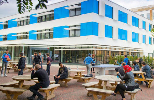
关于新不伦瑞克大学

位于加拿大美丽的东海岸的新不伦瑞克大学(UNB)是加拿大最古老的英语大学,该校是研究和创新的领导者,专注于创业的成功。提供超过75个本科和研究生课程,学生与教师的比例为15:1。新不伦瑞克大学(UNB)还拥有加拿大第三高的学生毕业率。每两个从高中直接升入新不伦瑞克大学(UNB)的学生中就有一个获得奖学金。该校每年提供超过900万加元的本科生奖学金。提供24/7的学术和个人支持,学生在安全的环境中得到帮助,大学随时提供安全服务。加拿大新不伦瑞克省新不伦瑞克大学(UNB)在加拿大的新不伦瑞克省有两个主要校区:一个在弗雷德里克顿,一个在圣约翰。该省生活成本低,拥有许多海滩、公园、湖泊和其他自然美景。Travel + Leisure杂志将新不伦瑞克省评为2020年最值得去的50个地方之一。从这里出发,乘飞机一个半小时可到达蒙特利尔,两个小时可到达多伦多,开车到波士顿需要六个半小时。弗雷德里克顿校区成立于1785年,圣约翰校区成立于1964年。这是新不伦瑞克省两个最大的城市。这两个校区都是小而友好的,来自100多个国家/地区的本科生加起来超过10000人。学生的经历是有趣和难忘的,大学有120多个俱乐部和社团可供学生加入。由于注重社区和热情的文化,学生在课堂内外很容易建立起持久的友谊。
本校相关课程


其他相关课程
在线提交申请
请详细填写您的申请材料
请选择
请选择
请选择
请选择
请选择
IDP在取得您的同意前,将不会提供您的资讯给其他机构