


- IDP China>
- 课程库>
- 自然科学>
- 自然科学与物理学>
- 地球科学>
- Master of Science in Geographical Information Systems and Remote Sensing
地理信息系统和遥感科学硕士
Master of Science in Geographical Information Systems and Remote Sensing

 爱尔兰
爱尔兰
学历文凭
Masters Degree (Taught)

专业院系

开学时间

课程时长

课程学费

国际学生入学条件
TOEFL iBT - 90 (Listening - 20, Reading - 19, Speaking - 21, Writing 20)
Candidates must have obtained at least a Second Class Honours degree or equivalent in a subject related to that of the MSc programme, e.g. Geography, Geology, Environmental Sciences, Computer Science, Physics, Maths, Engineering or a cognate discipline.
Graduates with equivalent qualifications in related areas of science and technology can be considered for places following inteview and/or assessment by the Director of the MSc in Geographical Information Systems and Remote Sensing Programme. The programme Director and/or the College of Science, Engineering and Food Science, UCC must approve candidates. The number of places is limited and selection will be based on academic achievement, relevant work experience, a personal statement from the applicant and/or an interview.
IDP—雅思考试联合主办方

雅思考试总分
6.5
- 雅思总分:6.5
- 托福网考总分:90
- 托福笔试总分:160
- 其他语言考试:Pearson PTE - Minimum Score of 63 with no section score below 59<br>Cambridge Proficiency Exam - Grade C<br>Cambridge Advanced Exam - Grade B
CRICOS代码:
申请截止日期: 请与IDP联系 以获取详细信息。
课程简介
The MSc in Geoinformatics addresses the growing need for science-trained postgraduates who are technically aware and competent to work in the field of geoinformatics, particularly as applied to environmental and resource management. This twelve month full-time course of study covers both the theoretical and practical aspects of geoinformatics, including Geographical Information Systems (GIS), Remote Sensing (RS), satellite navigation systems, cartography, visualisation, programming and web services. The course consists of 60 credits of taught modules, followed by independent research towards a dissertation worth 30 credits. In addition to the taught modules, you will have the opportunity to meet practitioners through regular seminars led by experts in the discipline from Ireland and abroad, visits to local geoinformatics enterprises and attendance at relevant Irish conferences. With an MSc in GIS and RS, you will be highly sought after by employers on graduation, and many of the graduates of this programme have found jobs within weeks of graduating and are still employed in the sector several years later. The course introduces you to the foundational concepts of GIS, RS, programming and cartography in the first teaching period, with lectures and practical classes which explore the underlying principles of the subjects. These skills are developed in the second teaching period with more advanced digital image processing, spatial analysis and geocomputation, again taught through lectures and practical classes.
相关申请
 预科
预科- 奖学金
 实习机会
实习机会- 在校学习
- 跨境学习
- 校园授课-线上开始
- 在线/远程学习
开学时间&学费
学费信息仅供参考,请与IDP联系以获取详细信息
| 开学时间 | 时长 | 学费 | 地点 |
|---|---|---|---|
| 暂无 | 暂无 | 暂无 | 暂无 |
学校排名

世界排名301
数据源:
泰晤士高等教育世界大学排名
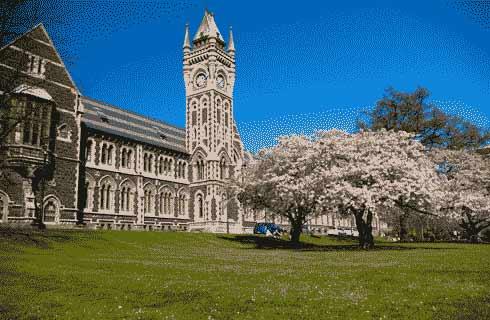
关于爱尔兰国立科克大学

UCC是一所世界领先的大学,以提供优秀的授课型学习项目和支持全球重要的研究社区而倍感自豪。大学的校风以促进思想多样性、知识交流和职业抱负为中心。大学与世界各地的数百所其他机构合作,拥有来自世界各地的数千名国际学生。UCC提供的16个学科领域在全球排行榜名列前茅,曾五次荣获星期日泰晤士报授予的''爱尔兰年度大学''称号,名列全球大学前2%。科克城是一座无与伦比的学习和发展之城。该城最近被命名为''联合国教科文组织学习之城'',以表彰其对卓越学习的承诺,科克是一个坐落在壮丽自然景观之中的文化中心和商业中心。UCC与爱尔兰其他地区、英国和欧洲有着奇妙的联系,无论对个人、学术或专业机构而言,UCC都是探索欧洲大陆的最佳场所。自1845年建校以来,UCC从未停止成长、发展和创新的脚步。除了卓越的研究、可持续发展的校园和全新的校园设施,大学还是来自世界各地的独特教职员工和学生社区之家。就读UCC就意味着可尽享欧洲最友好和最生气勃勃城市之生活。
本校相关课程
当代宗教文学硕士
学历文凭
Masters Degree (Taught)
开学日期
课程费用总额
文学士(荣誉)-应用心理学
学历文凭
Bachelor Degree with Honours
开学日期
课程费用总额

文学士(荣誉)
学历文凭
Bachelor Degree with Honours
开学日期
课程费用总额

犯罪学硕士
学历文凭
Masters Degree (Taught)
开学日期
课程费用总额

文学士(荣誉)-艺术(国际)
学历文凭
Bachelor Degree with Honours
开学日期
课程费用总额

文学士(荣誉)-艺术-音乐
学历文凭
Bachelor Degree with Honours
开学日期
课程费用总额
其他相关课程

莫纳什大学预科课程-扩展
 蒙纳士学院
蒙纳士学院学历文凭
Foundation
开学日期
课程费用总额

气候科学哲学博士(研究)
悉尼新南威尔士大学学历文凭
Ph.D.
开学日期
课程费用总额

理学学士(矿物地球科学)
阿德莱德大学学历文凭
Bachelor Degree
开学日期
课程费用总额

气候变化适应硕士(研究)
阳光海岸大学泰晤士高等教育世界大学排名:595
学历文凭
Masters Degree (Research)
开学日期
课程费用总额

地球科学学士
新英格兰大学学历文凭
Bachelor Degree
开学日期
课程费用总额

哲学硕士(国际卫生)
科廷大学泰晤士高等教育世界大学排名:256
学历文凭
Masters Degree (Research)
开学日期
课程费用总额